Hiking experiences
Martijn's homepage
China - Peru - USA - The Netherlands - Spain - South Africa - Argentina
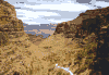
Zhang Jia Jie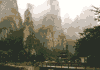
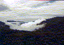
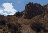
Zhang jia jie is an national park or Wulinyuan scenic area is situated in Hunan province in south of China. To reach it you have to make a train journey to the station of Zhang Jia Jie and after that a few hours drive by minibus. But the landscape is amazing, those high straight pillars. When your on top of one you see the mysteriousness because of the fog that surrounds the valley around them most of the time. Although for the Chinese this is a touristic area not many foreigners are seen there. This means that you have to watch for people that want to take advantage of that. Further the only map that was available had descriptions with Chinese characters. This wasn't that big of a problem because the park is covered with paved pathways so you can find your way easy. To get from one point to another means you have to climb a peak most of the time. Because those mountains are like pillars that just were pushed from the earth the walls are steep. So you have to stick to the paths and you're in for a lot of stairs. In the park are places to stay so you don't have to go back but be sure to find one for dark because ours didn't have electrical power and it was hard to find a way around in the dark. |
|
The inca trail to Machu picchu 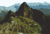
Although there are many beautiful parts of Peru to hike (the Colca canyon to name one) you have to be some what acclimated to go on a hike in the Andes. So at the end of my journey I went on a 3 day hike from 'km 88' to Machu picchu. It's along the ancient spiritual inca route and a perfect way to get a good feeling about Machu picchu. We went with a guide and 'sherpa's', but you can do it on your own. The route is very beautiful and only the second day is heavy. On that day you have to go over a pass of 4200 m. You have to camp because there are not that many places to stay and a lot of people that do the route. |
|
| National parks
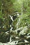
The south rim of the Grand canyon I walked the bright angel trail and part of the south kaibab trail, all the way down to the Colorado river. Although it's not recommended to do that in one day, you can do it if you are in good condition and start early (start at sunset like I did, it's early but you have enough time and don't have to walk in the heat all the time). I hiked in July so you have to be careful of the heat and drink a lot, the trail has enough drinking places to fill a bottle. Be careful not to make the mistake of going further down, because you start going down and the only way out of the canyon is the same steep way up! So watch the hours. But it's very fulfilling to walk all the way to the river. The waterfalls at Yosemite I hiked in most of the national parks in the west of the USA and they were all beautiful, but the one at Yosemite crossing two waterfalls was one of the best. The path and trail are not difficult (except one part where the road was more like climbing rocks) but the scenery is magnificent. Shenandoah national park part of the appalachian trail I hiked a few of the trails in Shenandoah national park. I stayed at the campsite 'big meadows' and walked large parts of the appalachian trail. The trail it self stays most of the time on the highest point of the park (same goes for the skyline drive, the road through the park) so you have to remember that you start going down when your walking away from the trail and at the end of your walk have to go up again. It's possible to make roundtrips of connecting trails and it's worth doing that. You see beautiful waterfalls and streams in the forest. The map from the Potomac appalachian trail club (no 10) was very useful. |
|
De lange afstandspaden (long distance walk routes)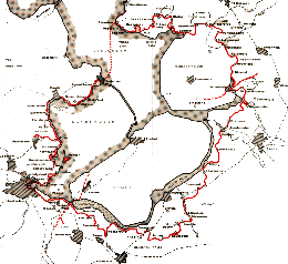
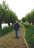
The association of long distance walks (LAW) in the Netherlands has laid out long distance routes (about 4000 km) all the way through the Netherlands (to go from north to south of the Netherlands is only 300 km!). Those routes are marked with red and white and go cross the country. There are also good books with descriptions of the routes (in Dutch) available. The routes are divided in parts reaching from 4 till 8 km Zuiderzeepad Beside the 'pietepad' this is one of the most famous routes of the
LAW. It encircles the water and land that used to be sea. I walked
some parts in the north and some parts in the south and south east.
The route is beautiful and never the same. You walk along a dike,
through forest and in grassland. Pictures of some part of the Zuiderzeepad Graaf Floris V -pad Early this year I started to do the route called the 'Graaf Floris V-pad' which is an old route through the 'green' heart of Holland. We started out at Muiden which is famous for it's fort from count Floris days. The total route is over 200km and we covered the flowing: In februari we did Muiden - Ankeveen, which is along the river 'Vecht' and you see some of the ex-peat area, which is now beautiful water In march we went on from Ankeveen - Loenen, which is all ex-peat area. We skipped a small part (which we want to do later) and started at
Breukelen in april and walked along the 'hollandse dijk', which is
all very old polder to end in Woerden along the 'Oude Rijn'. You could
see the summer coming in all the trees along the way. In may we went on from Woerden to Vlist, actually we went the otherway from Vlist to Woerden and did some more km then before. In high summer we walked also in the opposite direction the part from Nieuw Lekkerland behind the dikes to Schoonhoven where we crossed the Lek and completed our tour after some drinks in Vlist. In september we completed the part we skipped earlier between Breukelen en Loenen. From Loenen back to Breukelen we walked on the otherside off the beautiful Vecht. In november we walked a weekend and we started at Nieuw Lekkerland and walked to the Abblasserwaard and seeing the windmills at Kinderdijk. We stayed in the budget hotel in Dordrecht 'De Hollandsche Biesbosch' and continued the second day through parts off the Bieschbosch. Allthough it was november and bare it was still nice to walk all those 'tiendweggetjes'. Up till now we did 25 off the 42 parts and walked over 130km and still have about 100km to go before we reach Bergen op Zoom Pictures of some parts of the Graaf Floris V pad |
|
Basque region 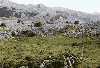
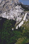
The plains of Urbia and Aizkorri mountain range We started our hikes from the village of Aranzazu (700m), which is not more then a monastery and a two hotels. From there you have to climb to 1100m through the woods, which are beautiful and green. When you cleared the woods you arrive on the plains and see the amazing rock formations carved by erosion of the limestone.When you climb further to the tops of Aizkorri (1500m) you have a beautiful view of the different types of mountains that are there, The springs of Urbasa Near the village of Zudaire is Nacedro de Urbasa a park where all the water from the Sierra Urbasa ends on the way down. Through the limestone it carves it way down to become a well. The hike is simple if you stay within the park.The basins of ice cold water are beautiful blue (and cold!). If you walk up to the Urbasa-plateau you can see famous vultures. The walk from Spain to France (from Ochagavia to Larrau) We started in Ochagavia (880m) and climb our way up to Collado Ollokia (Sierra de Abodi) you start in the woods and on the sierra it becomes heathland. You can see vultures and cows or sheep there. You see also the 2014m (according to the Spanish) or 2017m (the French tell us) high Pic de l'Ohri. To climb it is not hard if you go the Spanish side up. If there is not any fog (and beware of that) you can go the French side down but it's very steep and not easy. The last part is through the woods to Larrau. You crossed a border so be sure to have a passport with you. Andalucia Sierra Nevada In October off 1999 I went on an Hiking trip through the Sierra Nevada in Andalucia. We started at Busqitar and did some hiking around there. Although we originally should be walking from place to place we didn't managed that and so we hiked in the opposite direction to Bubion and took the bus back. We did our original route to Trevelez by following the GR-route, But we needed a map and compass to end up in Trevelez. From Trevelez we hiked up to the higher parts and stayed at the refugio at 2500m. The refugio was new and good accept for the rather small breakfast and lunch packets. From there we attempted to hike to the top off the Mulhacen (3478m) but the bad weather made us go back before we reached the top. Not that we could see much in the rain and snow. But on our way back we did see mountain goats. The last part we hiked down to Bubion.
|
|
Cederberg wilderness area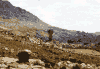
We stayed at kromrivier in the south of the wilderness area. It is a place with a camping and several guesthouses that are kept by the local farmer and also preserver of that part of the area. She is a good starting point to get information. Not only on the weather (because she was right about the heat) but also on the trails. There are also maps of that part and an overall map, she can provide. The maps are outdated and not all the routes are there. But if you stick to the main route to the cross or the pools. There is not trouble. Especially the cross (in my opinion it looked more like a fist) is worth seeing. Swartberg Between the little Karoo and the Karoo, near Oudtshoorn lies the
Swartberg mountain range. First of all it's famous of it beautiful
pass that you can drive through on the way from Prince Albert to Oudtshoorn
or v.v.. But there are also some hiking trails laid out in the area.
We hiked a round trail from the camping 'De Hoek' . There you can
also get a good detailed map of the area. The trail is beautiful and
a good walk. Although we didn't think it at first it is good marked.
The trail moves up and down through some 'kloofs'. On the map you
can see marks of water place. We didn't find them but there are some
water streams on the way. But if you only day hike like we you don't
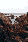
need them because you can take enough with you. Garden route Along the western cape and part of the eastern cape you find an area called 'the garden route'. It's a beautiful sea shoreline were you have many trails laid out. The most famous is the 'Otter trail', but we hiked some near Knysna. First we did a trail that began in the mountains and took as to the shore line were you could see beautiful red colored stone formations. On, between en through the stones we followed the shore and some miles further on climbed up again. This is a typical site along the garden route and a must. We also went on the 'mole' trail which was along some lakes (vlei) and completely different from the coast. Beautiful and with a lot of holes and fortunately for us no snakes. We also did one of the elephant hikes in the woods. These woods are very old and full of noises and strange plants. We didn't see any elephant despite the warnings. Montagu, the Cogmanskloof The last hike we did in South Africa was near Montagu a nice restful town between the mountains. The hike trough the 'kloof' was nice but not special at first. We had to climb a steep part. Halfway we saw a road and heard the noise of it. Maybe if we hadn't already hiked for two weeks the disappointment would be less. But near the end there were some beautiful sites between the mountain and the straws. And the view of Montagu was nice to. Tafelberg In and around Cape town you find the 'Tafelberg' mountain range. You can hike from town up or take the cable and hike down. Unfortunately I had to little time to see much of the area. I walked around Lion's head and took the cable up Table mountain itself, but you can do much more hiking out of town.
|
|
|
Los Glaciares On our trip trough Patagonia and halfway to the most southern part of Argentina (Tierra del Feugo) we went to the Andes and to the national park 'Los Glaciares'. We started from the town called Chalten to the campamento Poincenot. It was a beautiful walk with a good view of what to come and a view of the Fitz Roy. In the afternoon I also went up to the viewing point and these points are worth visiting because of the lakes and glaciers. but it was steep and asked a lot of energy. The second day we had a long walk with all our luggage. Not to heavy but a nasty river to cross. Our camp was near Laguna Electrico whixh was also beautiful to see. The third day was less beautiful we walked a long way along the road to Chalten. The day after we also went in a fast walk from Chalten to Mirador Maestri to have a look at the Torres and back. A good walk and a beautiful scenery Parque Nacional Tierra del Feugo Near Ushuaia on tierra del feugo (fire island) on the most southern part of the world is a national park. we hiked for one day along the coast (the beagle channel) more land inwards to lago Roca. A clear path and a nice one day route. |
If you have remarks or additional information mail me, or if you want your own experience published here:
![]() Mail to wo@dds.nl or join
the WebRing
Mail to wo@dds.nl or join
the WebRing
 
|
| This Hiking review webring site owned by RingMaster Sipan. |
| [ <<5| << | Previous | Next | > > |>> 5 | Random Site | List Sites ] |